<<PREVIOUS -
HOME -
CONTENTS -
NEXT>> -
![]()
<<PREVIOUS -
HOME -
CONTENTS -
NEXT>> -
![]()

|
All Sky Maps
|
Sky maps are used to located stars and other objects in the sky just like a world map is used to locate countries, states and cities.
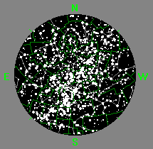
There are many types of sky maps just as there is may types of land maps. Sky maps cover various amounts of the sky. One of the most useful sky map is a sky map that shows the entire sky that can be seen at once. This assumes you have unobstructed veiwing horizons. These sky maps are implemented as circle sky maps with the horizon at the edges of the circle sky map and the point directly overhead is located at center of the circle sky map. The point directly over head is called the zenith. Half way from the center of the circle sky map (zenith) to the circle sky map edge (horzion) is same as viewing the sky half way fron directly overhead to the horizon.
A world map is used to learn the locations of countries and major cities of interst. Simularly, the circle sky maps are use to learn the locations in the sky of constellations and bright stars. To keep the circle sky map useable only the bright stars are shown. Just like we have country boundaries on a world map so has the sky been divieded into areas called constellations. The complete sky is divided into 88 constellations. The constellations vary in size and shape.
A circle sky map show the positions of the stars for a certain date, time and observing location. Just like the Sun moves across the sky during the day the stars will move across the sky during the night. Most of the stars will rise in the east and set in the west. The northern stars will circle the Polars in a counterclock wise direction. Therefore, different sky maps are use through out the night to indicated the positions of the stars.